

LIDAR stands for Light Detection and Ranging which is a Remote Sensing technology used to measure the features of the earth surface, create DEM (Digital Elevation Model). LIDAR uses laser beams to hit the target and record back the reflected energy. It is the active sensor which generates numbers of pulses. This reflected pulses gives detail information of the objects. For example Laser pulse will hit the top, middle and bottom part of the tree to generate tree model. A LIDAR instrument consists of a laser, a scanner, and a specialized GPS receiver. Helicopter or plane is the most common platform for this instrument.
1. Global Mapper LiDAR Module
1. Global Mapper LiDAR Module

Global Mapper is the easy GIS software that is suitable for both new and advanced users. This software has all the main tools necessary for the analysis of the GIS. It's extremely easy to use.
LIDAR Module: This is an optional Global Mapper purchase module. This adds the LIDAR advance feature to the software. Some of the advanced LIDAR features include automatic cloud point classification, extraction of features, cross-sectional viewing and editing, dramatically faster surface generation and more. For details on the module, please refer to their official website. It enables users to viewpoints in the cloud acquired via RIEGL laser scanners. It's an IPad application that needs iOS 5.0 or higher. It shows true point cloud 3D color. The following are some features of this application.
- IPAD Point Cloud Viewer: View 3D Point Clouds.
- Touch Navigation: the Navigation touch screen.
- Augmented Reality: Print a reference image and experience point clouds in Augmented Reality.
- Single color and True color mode for point clouds.
- Adjust point size.
- Orthographic and Perspective visualization mode.
3. Lizardtech – LIDAR Compression Tool
This company has many valuable tools for the GIS system. LiDAR Compressor is one of the popular tools for LIDAR data. It compresses the LIDAR data which reduce 25 percent of the total size while retaining every return. Compresses data in the format of MrSID. It's also very easy to handle.

4. LIDAR in ArcGIS
Arcgis is a GIS leader and has advanced point cloud LIDAR tools. Tools help advance GIS analysis, decide and use scientific research. ESRI magazine has an interesting topic to work with LIDAR, you can learn how to use LIDAR image in Arcgis.
Other resources:

5. LP-360

This is an extension to the ArcMap, which greatly transforms the LIDAR processing capability. It can be used in very large sets of data. LP360 offers three capabilities. It has quick visualization tools and derived product generation. Also in advanced features, it provides programmed ground cataloging and building footprint abstraction.
6. FME
The FME, known as the function manipulation engine, has hundreds of data transformation tools. Some of these tools are used for data from the LIDAR point cloud. You can quickly and easily transfer LIDAR data to other arrangements. Find out more approximately LIDAR and SAFE products. ReadMore...
7. GRASS GIS – LIDAR Tools
Grass is the most popular open source GIS software with LIDAR tools for point cloud processing and for GIS analysis using the output product. The tools support the basic and advanced processing and analysis of LIDAR data. More help files are available in GIS wiki 
8. ENVI – LIDAR
ENVI stands for Environment for the visualization of images and is one of the most popular remote sensing software. The majority of the remote sensing experts use it, but not for the GIS. ENVI LiDAR allows you to create 3D visualizations and easily extract important LiDAR point cloud data features and products. Then you can export data into other your handy GIS software.

9. BentleyPointstools V8i

The Bentley Points tools are a stand-alone online software capable of processing point cloud data. It quickly creates point clouds for distribution and reuse. Read more
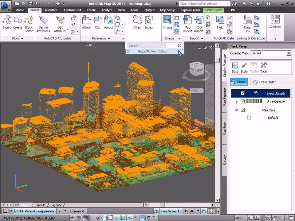
10. AutoCAD MAP 3D – LIDAR Features
Point clouds are large data sets composed of 3D point data. Aerial LiDAR (Light Detection And Ranging) laser scanners are the most common instruments used to collect geographic point cloud data.
Geographic LiDAR data is most commonly available in LAS (LiDAR Aerial Survey) or ASCII (.xyz) format. LAS is an industry standard file format defined by the American Society of Photogrammetry and Remote Sensing that includes a system of point classification. A processed LAS file may have points classified as bare earth, high or low vegetation, building, and so on.
Global Mapper is the easy GIS software that is suitable for both new and advanced users. This software has all the main tools necessary for the analysis of the GIS. It's extremely easy to use.
LIDAR Module: This is an optional Global Mapper purchase module. This adds the LIDAR advance feature to the software. Some of the advanced LIDAR features include automatic cloud point classification, extraction of features, cross-sectional viewing and editing, dramatically faster surface generation and more. For details on the module, please refer to their official website.
2. RIEGL RiALITY – IPAD App
It enables users to viewpoints in the cloud acquired via RIEGL laser scanners. It's an IPad application that needs iOS 5.0 or higher. It shows true point cloud 3D color. The following are some features of this application.
This company has many valuable tools for the GIS system. LiDAR Compressor is one of the popular tools for LIDAR data. It compresses the LIDAR data which reduce 25 percent of the total size while retaining every return. Compresses data in the format of MrSID. It's also very easy to handle.
Arcgis is a GIS leader and has advanced point cloud LIDAR tools. Tools help advance GIS analysis, decide and use scientific research. ESRI magazine has an interesting topic to work with LIDAR, you can learn how to use LIDAR image in Arcgis.
Other resources:
Using LIDAR in ArcGIS 10.1:
A quick tour about LIDAR:
5. LP-360
This is an extension to the ArcMap, which greatly transforms the LIDAR processing capability. It can be used in very large sets of data. LP360 offers three capabilities. It has quick visualization tools and derived product generation. Also in advanced features, it provides programmed ground cataloging and building footprint abstraction.
6. FME
The FME, known as the function manipulation engine, has hundreds of data transformation tools. Some of these tools are used for data from the LIDAR point cloud. You can quickly and easily transfer LIDAR data to other arrangements. Find out more approximately LIDAR and SAFE products. ReadMore...
7. GRASS GIS – LIDAR Tools
Grass is the most popular open source GIS software with LIDAR tools for point cloud processing and for GIS analysis using the output product. The tools support the basic and advanced processing and analysis of LIDAR data. More help files are available in GIS wiki
8. ENVI – LIDAR
ENVI stands for Environment for the visualization of images and is one of the most popular remote sensing software. The majority of the remote sensing experts use it, but not for the GIS. ENVI LiDAR allows you to create 3D visualizations and easily extract important LiDAR point cloud data features and products. Then you can export data into other your handy GIS software.
9. BentleyPointstools V8i
The Bentley Points tools are a stand-alone online software capable of processing point cloud data. It quickly creates point clouds for distribution and reuse. Read more
10. AutoCAD MAP 3D – LIDAR Features
Point clouds are large data sets composed of 3D point data. Aerial LiDAR (Light Detection And Ranging) laser scanners are the most common instruments used to collect geographic point cloud data.
Geographic LiDAR data is most commonly available in LAS (LiDAR Aerial Survey) or ASCII (.xyz) format. LAS is an industry standard file format defined by the American Society of Photogrammetry and Remote Sensing that includes a system of point classification. A processed LAS file may have points classified as bare earth, high or low vegetation, building, and so on.


Are you searching for the best lidar scanning service in Texas? Then you should visit Onsite3D website. Because they provide the best lidar scanning service in Texas. Best lidar scanning service Houston, Texas
ReplyDeleteThe course furnishes you with industry associations and systems administration openings. ExcelR Data Science Courses
ReplyDeleteTruly, this article is really one of the very best in the history of articles. I am a antique ’Article’ collector and I sometimes read some new articles if I find them interesting. And I found this one pretty fascinating and it should go into my collection. Very good work!
ReplyDeleteData Science Institute in Bangalore
Study ExcelR Business Analytics Courses where you get a great experience and better knowledge.
ReplyDeleteBusiness Analytics Courses .
You have cool stuff and you keep every one of us updateddata science certification
ReplyDeleteThank Mr tejaswini We need your support also on YouTube please subscribe us. https://www.youtube.com/channel/UCDWqBtWt7V4sqYLk7MJH7kw?sub_confirmation=1
DeleteThis post is very simple to read and appreciate without leaving any details out. Great work!
ReplyDeletedata scientist course in hyderabad
I am impressed by the information that you have on this blog. It shows how well you understand this subject.
ReplyDeletedata scientist course
Outstanding article! I want people to know just how good this information is in your article. Your views are much like my own concerning this subject. I will visit daily your blog because I know. It may be very beneficial for me Yeezy Gap Black Jacket
ReplyDeleteThis Blog is very informative for us. Thanks for writing about it. In this article, some examples help me in applying in daily life. amazing You have explained each and everything very well in detail. I hope you will write more pieces which help us in our daily routines. kyle kuzma pink sweater
ReplyDeleteIt is the intent to provide valuable information and best practices, including an understanding of the regulatory process. fud crypter
ReplyDeleteThe first and foremost thing when learning data science is the discovery of data insight. In this aspect, the raw data is analyzed to gather information from raw data.
ReplyDeletedata science course in gorakhpur</a
Wow great blog article. Really thank you! Awesome. data archiving near me
ReplyDeleteI loved your blog post. Thanks Again. Great. data archiving services
ReplyDelete